


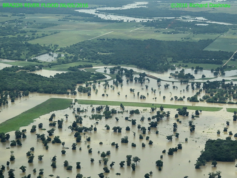
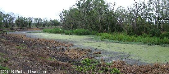
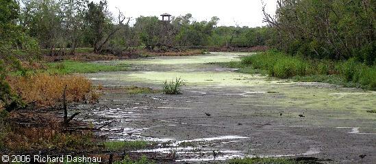
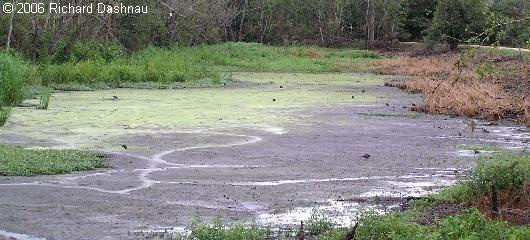
06/21/2015
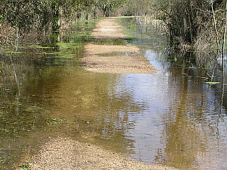
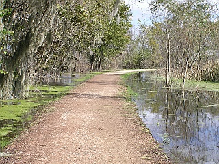
Water has receded more from Brazos Bend State Park, leaving the
roads and most of the trail clear. The river didn't rise as far and as
fast as had been forecast. I was able to go out the the park for
another guided tour. I
took a few pictures as I went on the tour around 2 lakes. 40 Acre
Lake had a lot of debris. This coming weekend will be the first in
weeks that volunteers will be allowed to work in the park--assisting
various cleanup duties. The park is still closed, and may be for
another few weeks. Check the state park page, the state facebook page,
and the volunteer website for more news. --
-- -
- --
--
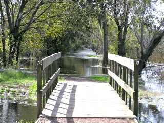
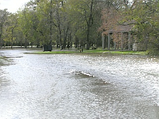
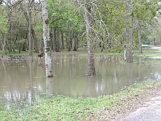
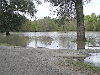
40 Acre lake looking East 6/21/15
40 Acre Lake near tower 06/21/2015 Spillway Trail looking at Bridge 6/21/15
Spillway Bridge 06/21/2015
Gator resting on the
trail in front.
Water level can be seen on top rails. --
-- -
- --
--
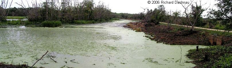
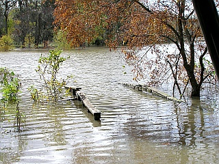
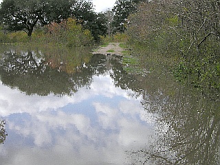
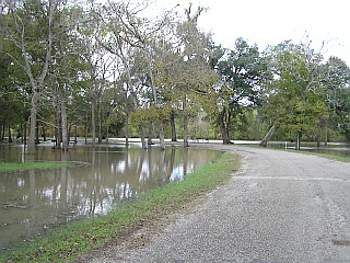
Spillway Trail just past bridge 6/21/15 Spillway Trail towards Elm Lake 06/21/2015 Pilant Slough Trail at Elm Lake 6/21/15 Water into 40Acre from Pilant Slough 06/21/2015
Dead
area shows water level. Stick=6 feet
Water flowing into the lake as water rose again. --
--
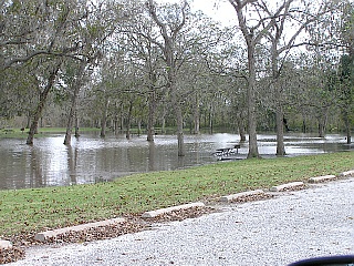
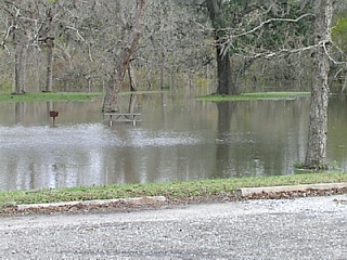
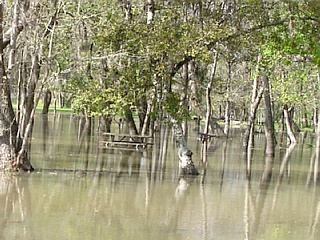
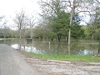
Birds Eating fish South 40Acre 6/21/15
Dead Fish South 40 Acre 06/21/2015
Dead fish probably killed by silt suspension in floodwaters. Many bass, perch, crappie, bluegill.
06/14/2015
Water has receded more from Brazos Bend State Park, leaving the
roads and some of the trail clear--but many trails were still under
water. I was able to go out the the park for another guided tour.
I
took a few pictures. Some of them fit in with the large group of images
below. These few show where the water had been. In the picture of
Big Creek, the green ends where the water had been. In the wood yard,
the silt on the rope shows how high the water had been.
Since the
14th, tropical storm Bill dumped a lot of water throughout Texas.
As I write this (6/18/2015) they are forecasting that the Brazos River
will rise to about 50' at the Rosharon gage sometime Saturday morning
(6/20/2015). This will probably cause the park to be flooded again.
Tentative plans were for the park to reopen 6/22/15--but if the
water rises as predicted, it probably won't reopen until sometime in
July. The graph
below shows how the Brazos River height changed from May through July.  -----
----- ---------

Big Creek between NC & Elm Lake 6/14/15
In the Wood Yard 06/14/2015 Brazos River levels at Rosharon
06/07/2015
Brazos Bend State park was closed for business on 05/27/2015. Lots of
rain throughout Texas caused flash flooding in many areas, and
eventually raised the water level in the Brazos River. The water level
in the Brazos River raised to 51.4 feet at Rosharon gage--about 2 river miles downstream from the mouth of Big Creek. The high water caused backflow into Big Creek,
which winds through the park. Big Creek overflowed, and pushed water
into Pilant Slough, which also overflowed and filled the remainder of
the park. Water levels in the park started going down sometime on
6/6/2015. On 06/07/2015 park management allowed for a "guided
tour" of the park for interested volunteers, so I was able to get
pictures of my own. Most of these are shown below. Note that
these were taken AFTER water had started to recede. I went
through my archive of older pictures, and tried to find images of
earlier times that corresponded to those I shot while the park was
under water. So the images are in sets, with the older image first,
followed by the recent flooded image. Some of the older images
are screen grabs from "action camera" footage I filmed from my car.
Park is still closed today (6/11/2015) -
- -
- --
--
40-Acre lake pier 2013
40-Acre lake pier 2013 40-Acre lake pier 6/07/2015
 -
- -
- --
--
40-Acre lake pier 2013
40-Acre lake pier 6/07/2015 40-Acre Lake Pier 6/14/2015
 -
- -
-
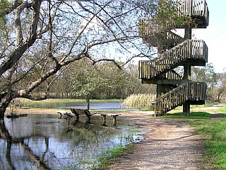
40-Acre Observation Tower 2013 40-Acre Observation Tower 6/07/2015 40-Acre Observation Tower 6/14/2015
 -
- -
- -
- -
-
Mile Stretch at curves sign 2014 Mile Stretch at curves sign 2015 Mile Stretch at 2 signs 2014 Mile Stretch at 2 signs 2015
 -
- -
-
 -
- ------
 -
- -
- -
- -
-
 -
- -
- -
- -
-

 -
- -
- --
--
 ----
---- ----
---- --
-- -
- -
-
Although
the
camera
shoots
1000 fps, captured frames are placed in a video file
formatted to play back at 30 fps--which results in slow motion
replay.
One second shot at 1000fps plays back at 30 fps, or 33.3 times
slower.
Shooting 1 second at this rate results in 33 seconds of viewing time,
and
this increases in proportion. 10 seconds shot at 1000 fps will give 330
seconds of viewing time (or about 5 minutes)--and so on. That means
that
I had a lot of "dead" video to look through. With the right software, I
can look at one frame at a time (which would take forever, ha ha) but
each
frame represents 1 thousandth of a second.
I
reviewed
the videos. I almost thought I didn't get anything, but finally found a
few flashes. Even at 1000 fps, the lightning was very brief. By
using
a number of video editing programs (Quicktime, Video Mach, Virtual Dub,
Windows Movie Maker) I was able to resize the frame, and to slow down
the
action even more.
After
resizing and slowing down the video, I captured frames from them. I did
no other enhancements or alterations to the images.
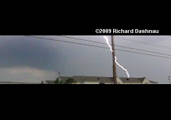
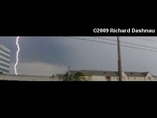
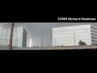
Today's
RICKUBISCAM
shows
the
view to the Soutwest of my position at the park.
The storm is moving left to right in the following frames, and the
lightning
strikes are South of me as I pan across. Below are the frame
captures. This stuff doesn't feature Buddha specifically, but she was
there when it happened.
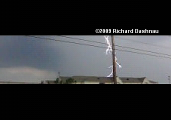
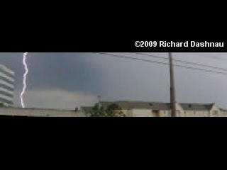
FIRST
BOLT STREAMS
DOWN
BRIGHT
PULSE!
IONIZED
AIR
MAINTAINS
GLOW
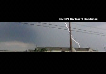
GLOW
FADES
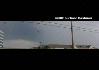
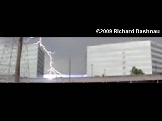
ESTABLISHING
SHOT
BETWEEN
STREAMERS
FROM
THE
GROUND?
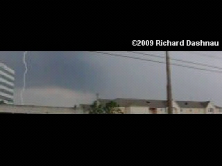
2ND
BOLT,
CONNECTION!
IONIZED
PATH
MAINTAINS.
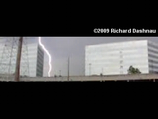
The
weird artifact near the ground in the second image seems to be
generated
by the camera--perhaps because of the brightness of the image at that
point.
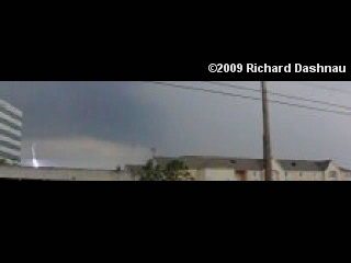
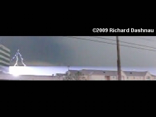
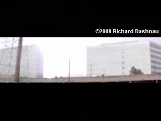
GLOW
FADES
RETURN
STREAMER
STARTS
FROM GROUND 2ND BOLT, SECOND
CONNECTION! THIS MAINTAINS
LONGER.
 -
- -
- -
-
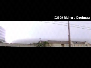
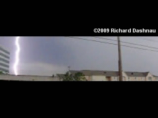
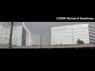
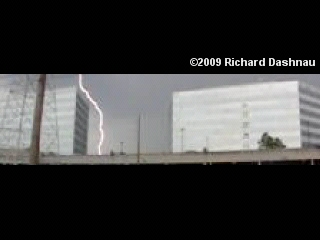
3RDBOLT,
PRIMARY
STREAMERS
3RD
BOLT,
CONNECTION!
IONIZED
PATH
MAINTAINS
RETURN
STREAMER
STARTS FROM GROUND.
The
weird artifact near the ground in the first image seems to be generated
by the camera--perhaps because of the brightness of the image at that
point.
 -
- -
- -
-
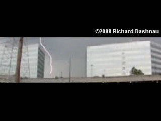
3RD
BOLT,
SECOND
CONNECTION!
IONIZED
PATH
MAINTAINS
GLOW
FADES
-
Although
these
bolts
are
bright, they were quite far away, judging by how long
it
took for the thunder to reach me. At first glance, it's somewhat
interesting
that the primary and return strokes have exactly the same shape--but
these
all happened in fractions of a second--long before air movement could
change
the shape of the ionization path. Lightning occurs when a high
charge
potential builds between two points (ground and air, or air to air).
The
current winds its way between these points until a primary connection
is
made. Then the energy rushes to equalize, but sometimes this can flow
one
way, then the other until the charges dissipate. The rushing energy
ionizes
(charges) the air, making it conductive and causing it to glow. The
surrounding
air is rapidly heated and expands, causing thunder.
I've
edited a video from these clips. It can be seen here: Lightning
at Danny Jackson Bark Park 1000fps wmv 5.1mb
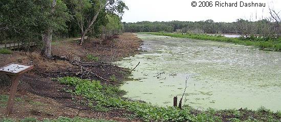
06/18/2006 I've recently made several references to the low water levels in the park. Here are a series of images of 40 Acre Lake, taken on 6/18/2006. These were shot from the North length of the 40-Acre Lake Trail, and were taken as I moved East to West, starting from the Hoots Hollow Trail. -----------------------
-- -------
 --
--
LOOKING EAST, FROM HOOT'S BENCH
ABOUT HALFWAY BETWEEN BENCH AND OBSERVATION TOWER
HALFWAY TO TOWER, LOOKING WEST.
For comparison, you can look at the material I shot in December of 2005 from not far from the halfway point I show in the images above. Even in December, the water level was lower than it should have been. You can look at this page, at the entry for December 4, 2005 to see some water in 40 Acre Lake, or look above that to the entry for November 28, 2004 to see what it looked like just before it got OVER filled and flooded. If only that could happen now!
-- -
-
AT THE OBSERVATION TOWER, LOOKING
WEST.
 --
--
AT THE OBSERVATION TOWER, LOOKING SOUTH
I really
hope that we can get a good rain soon. The Houston area has been getting
rain through June, but not much of it has fallen on the park.
November
28, 2004Today
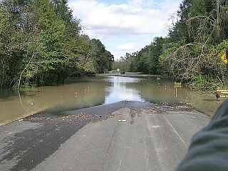
was certainly a NON-typical day at Brazos Bend State park. The Brazos River,
and Big Creek-which meet at the Southeast end of the park-were both swollen
with rainwater, and were much higher than usual. The Brazos River had breached
its banks, and Big Creek was backflowing into the park via Pilant Slough,
although it had already breached its banks in some areas. I was on the
trails in the morning, and it was a beautiful day.
---------------------------------------------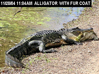
ALLIGATOR WITH SKIN
However,
the water slowly crept into the park. Here are some pictures I took as
I walked the park, and also did a short riding patrol with Chuck and Sharon.
I had scheduled two interpretive programs, or else I would have stayed
out on the trails longer. The picture above shows an alligator that had
come up onto the 40-Acre Lake trail (which hadn't flooded...yet) with a
deerskin in its jaws (I said the alligator had a fur coat. I didn't say
it was wearing it.)
The skin had probably gotten washed into the water by the flooding, where
the alligator had found it. The alligator moved back into the water and
slowly swam off when I got closer. Clicking on the images will
show them larger.
![]() -
- -
-
WITH SKIN, CLOSER
WATER FLOW AT 40 ACRE
40 ACRE HIGH
WATER
- ---
---
40 ACRE/PILANT
BRIDGE
OBSERVATION TOWER
 -
- -
- -
-
ELM LAKE PICNIC AREA
THAT'S BIG CREEK!
HALE LAKE PAVILION
 -
-
HALE LAKE FISHING PIER
HALE LAKE PICNIC
AREA
 -
- -
-
BLUESTEM TRAIL
ISLE OF BAD INTENT
FLOATING BADNESS
- -
-
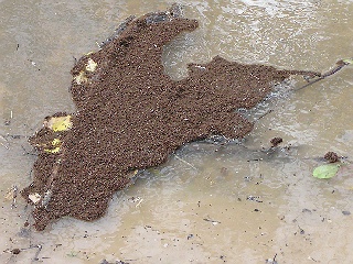
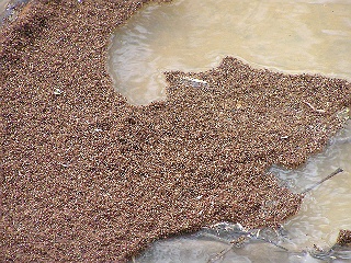
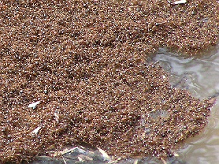
REALLY ANNOYED ANTS
FACING THE CAMPING LOOPS
As we
went around Bluestem and Red Buckeyee trails, we encountered a number of
floating ant mats. We stopped near one just long enough to get a few pictures
(see ISLE OF BAD INTENT, FLOATING BADNESS, and REALLY ANNOYED ANTS,
above). These are floating islands made entirely of Fire Ants. This one
was about 18 inches around. Here in Houston, mats of this type are a big
problem when we have high water.
The
flooded, displaced Fire Ants make a raft (or island) of their own bodies.
They are very much alive, and will swarm onto anything they can that will
get them out of the water. If they swarm onto something living, they "show
their gratitude" by stinging the hell out of whatever they've climbed on.
We moved on after a few pictures so we wouldn't risk the ant mat lighting
on our Kaboda, and from there onto us! 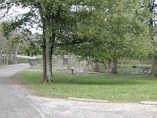 -
- -
-
CAMPING
LOOP
AWAY FROM THE
RIVER
NEARING BIG
CREEK
- -
-
NO CAMPFIRES TONIGHT
THAT'S BIG CREEK
AGAIN
These
pictures were all taken before 12:00 PM Sunday. It was an odd feeling to
ride around in the partly sunny, calm weather and see all this water slowly
rising.
The
water was still rising Sunday evening. If anyone is interested in visiting
the park this coming week,it would be a good idea to call the park first
and check conditions there. The last news I got (today, December
1) is that most of the park was under water.
----------------------------------- 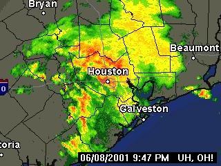
Figure 1.
I finished my meal,
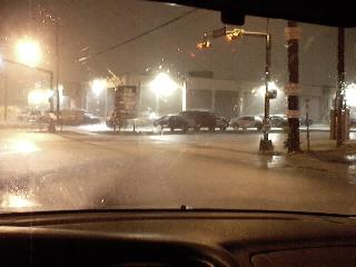
and drove home. On the way, I noticed that some of the streets started
developing high water. I stayed on streets I was familiar with, and those
I knew were higher--that is, that didn't dip under any overpasses, and
so on. As I drove on, I notice water starting to rise, and tried to take
some pictures with the digital camera I usually have with me. Since
I was still driving at the time, and the torrents of water made it difficult
to see clearly, and the low light conditions; most of the pictures just
didn't come out well. I made a detour near my apartment to go to an ATM.
I found myself on a side street with alarmingly high water. I then drove
home, and encountered more high water. On one of the main streets, the
water was rising (figure 2). I got off these streets as soon as possible,
and onto the lesser-traveled streets near my house. But, these weren't
much better. (figure 3.) Click on the images to see them larger.
----------- ---------------------------------------------
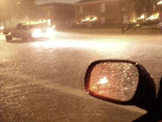
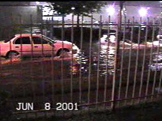
Figure 2
figure 3
This intersection is about a mile from my
house.
This intersection is about one block from my house. This is the
high
spot
It's hard to tell, but that's water, not road
surface.
in the road I'm on. That truck went in up over its headlights. So did I.
When
I got home,I logged on, and got the Doppler radar image shown in Figure
1. Not long after that,I grabbed my video camera and took some movie footage
directly outside my apartment door. Figure 4 (below)is an image from the
video.Click hereto
see the video clip.(flv video 2,519kb).
----- ---------------
figure
4.(click image to
enlarge)
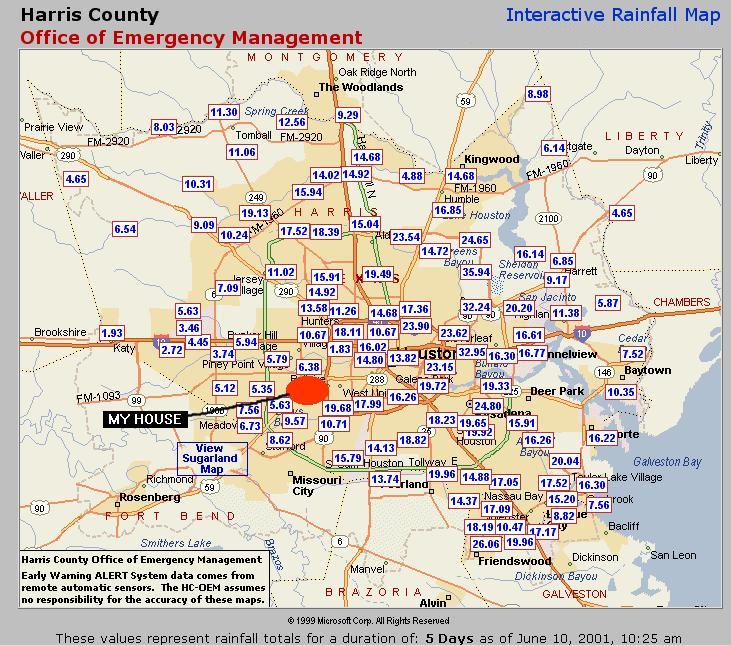
figure 5.
I
was very fortunate during this week. Take a look at the rainfall map (click
on figure 5). I've marked where I live. Note
that the heavy rainfall is not that far from where I am. In some
spots they recorded over 30 inches of rain since tuesday (June 5).
The heavy rainfall hit close to downtown Houston, and on the other parts
of town, about 20-25 miles away from me. Some of this occurred
nearer the Gulf of Mexico and the Ship Channel--effectively "downstream"
from where I am. Since they got so much water, though, the smaller amount
*I* received still caused flooding, since it had nowhere to go. I didn't
know any of this Saturday morning. I went about my business, and this was
mostly on the west side of town. I didn't see any current news media until
I turned on the TV Saturday evening. I *had* heard that the heavy rain
had disrupted newspaper deliveries, so I hadn't seen a newspaper. Although
I knew we'd had flooding (I'd even seen some of it), I had just assumed
that the water had receded much as it had done in my neighborhood.
Then, I received a huge shock when I turned on the TV. Every station was
covering the disastrous flooding. I don't know how much of this the
rest of y'all saw on the news, but on the local stations it looked terrible.
The
Houston Chronicle Online has a lot of coverage showing what happened this
city that I call home. To those of you that have never been here, the pictures
may not say much. To me, they are quite a shock. To see the
full story, go to their page covering the flood.
Click
on the link to get there: The
Great Flood of 2001.
Go back to my home page, Welcome
to rickubis.com
Go back to the See
the World page.